Use of satellite telemetry and remote sensing data for the identification of important habitats of migratory birds (Ciconia ciconia, Aquila pomarina)
Birgit Gerkmann
Zoologisches Forschungsinstitut und Museum Alexander Koenig,
Adenauerallee 160, D-53113 Bonn, Germany
Phone: +49 (0)228 9122234
Mail: birgit.gerkmann@gmx.de
Funding by "Deutsche Bundesstiftung Umwelt"
Aim of this study is the development of a new method to identify important habitats for migratory birds by combining satellite telemetry and remote sensing data. Telemetry data will be analysed to localize staging areas on the migration route or in the wintering grounds. By an overlay of telemetry and remote sensing data the study will develop a new tool for conservation research.
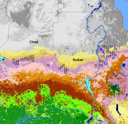
In cooperation with the MPI for Ornithology satellite data of 67 White Storks (Ciconia ciconia) could be analysed. Only high quality datasets with an accuracy of 5 km have been used. Reanalysing telemetry data with a newly developed algorithm provides an index to differentiate migrational and staging datasets. Ongoing investigations using GIS focus on the localization of these staging areas. First results show an importance of pre-wintering areas in the Sudan and Chad for the White Stork. Further important regions are located on the migration route and in wintering areas as in Botswana.
In addition telemetry data of tracked Lesser Spotted Eagles (Aquila pomarina) will be used. These data are collected by B.-U. and C. Meyburg for the most part not yet analysed.
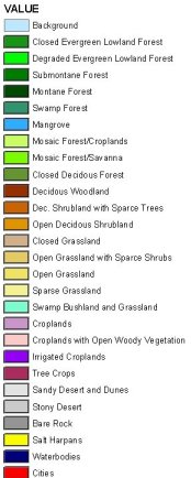
For the combination of telemetry data with remote sensing data so far, remote sensed data of the Africa Land Cover Characteristics Database and the Global Land Cover Project were obtained. First overlays with telemetry data of known wintering areas of two Eagles in Zambia and Zimbabwe show a preference for savanna and cropland areas. An overlay with selected telemetry data of the White Stork in Chad and Sudan show a preference for Woodland, Grass- and Cropland.
Ongoing work will focus on further satellite data from the MODIS satellite systems. These data give information about biomass and conditions of precipitation. Investigations will focus on correlations between change of vegetation (precipitation) and stopovers of the birds.
The results will be verified through field trips to at least two areas identified by this method.
|
|
|
The figure shows important staging areas of White Stork during migration in combination with the global land cover map 2000 of Africa (Mayaux 2003). |